| Name | GPS Coordinates | Miles to Next | Difficulty | Address | Portage | Parking | Bathrooms | Boat Launch Surface | Put in (River side) | Description |
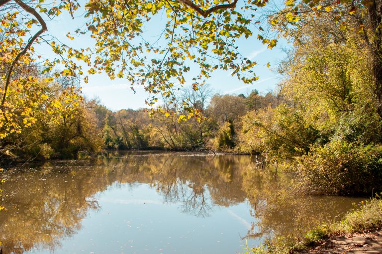
| Jessup’s Mill Access | 36.525703, -80.370423 | 6.1 Miles | Intermediate | 1565 Collinstown Road, Westfield, NC 27053 | – | Large gravel lot next to road and river access, no accessible spaces. Farm road cuts through lot | No | Wooden stairs under bridge leads to sandy embankment. Wood cartop launch. Not motorized boat access. | Right | Advanced Adventures: This section contains a series of six Class 1 & 2 rapids. In this section the banks of the river reach up to 100 ft creating a small gorge. Check Jessupmill.com for camping, music, and more! More info here: https://www.danriver.org/interactive-map |
| Hart’s Access | 36.514368, -80.302750 | 12.8 Miles | Beginner | 3647 North Carolina 704 Hwy W, Lawsonville, NC 27022 | – | Gravel lot off of heavily eroded loop driveway. No Accessible spaces | No | Concrete ramp at end of parking lot. Accessed by steep gravel driveway | Left | As you paddle, Big Creek enters from the right, Double Creek enters from the right, then the river takes a left turn. You will find steep rock walls. In late spring/early summer you will see lots of rhodendrons. More info here: https://www.danriver.org/interactive-map |
| Hanging Rock Access | 36.429985, -80.248259 | 5.2 Miles | Beginner | 1258 Flinchum Rd, Danbury, NC 27016 | – | paved lot | No | paved boat ramp | Right | This is a popular section. The Dan River Company is a short distance downstream of this put-in where you can rent kayaks, canoes and shuttle services. More info here: https://www.danriver.org/interactive-map |
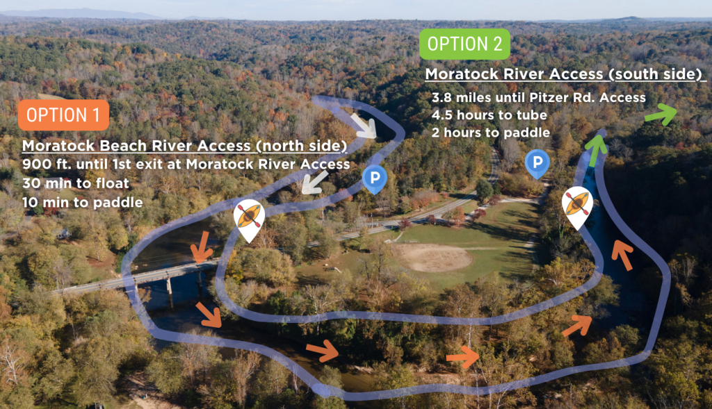
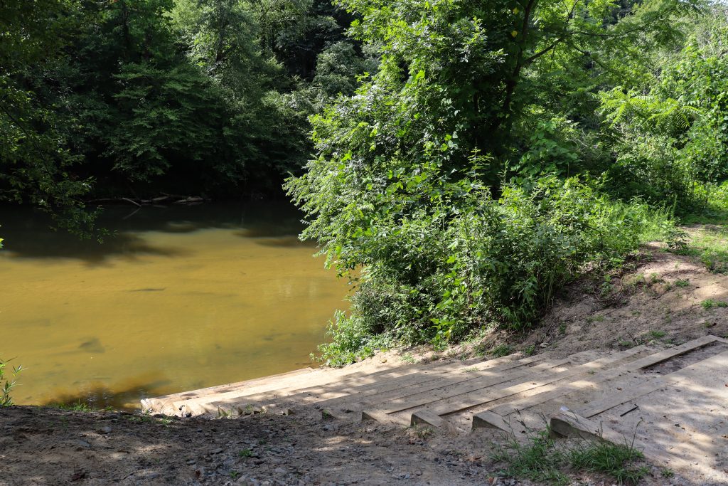
| Moratock Park Access | 36.409296, -80.195971 | 3.8 Miles | Beginner | 1077 Sheppard Mill Rd, Danbury, NC 27016 | – | Large gravel driveway leads to bank of river, ~200′ along river to a gravel parking loop. | 1 Porta-john near the parking loop | stairs lead down to water level across sandy embankment. No ramp, no handrails, no launch. | Left | Enter the park on the southern side of Shepperd Mill Rd. The river access is near the Moratock Iron Furnace. There are steps down to the river. Moratock Park has restrooms, a park, playground, 2 parkng lots, and a sandy beach. For a shorter trip see option 2 of the Family Friendly section of the Dan River in Paddle The Piedmont. More info here: https://www.danriver.org/interactive-map |
| Pitzer Road Public Fishing Access | 36.401827, -80.145831 | 5.3 Miles | Intermediate | 1285 Pitzer Rd, Walnut Cove, NC 27052 | – | Small paved lot | No | Concrete steps & concrete handicap ramp | Left | Sights Worth Seeing: The Pitzer Road access replaces the previous Snow Creek Access. This river access is often too low to paddle, so you may need to walk up the river some. Take-out river right. More info here: https://www.danriver.org/interactive-map |
| Hemlock Golf Course | 36.369400, -80.126753 | 9.2 Miles | – | 1232 Power House Rd, Walnut Cove, NC 27052 | – | Paved pullout into gravel shoulder next to access. No marked accessible spaces | No | gravel road leads to concrete ramp | Right | This lengthy section contains mostly class 1 paddling with a series of Class 2 rapids. When the water is low, go around the left side of the island (1.4 miles in) More info here: https://www.danriver.org/interactive-map |
| Pine Hall Access | 36.318836, -80.050041 | 7.1 Miles | Beginner | 1716 Pine Hall Rd, Pine Hall | – | Uneven gravel lot off of shoulder, grassy parking area in addition to that. | No | 2 muddy overgrown ramps drop down to the water. | Right | – |
| Madison River Park (Takeout) | 36.374784, -79.994377 | 2.9 Miles | Beginner | 643 Lindsey Bridge Rd, Madison, NC 27025 | – | Large gravel lot | 1 Porta-john | ramp | Right | This take out is before/upstream of the class 1 rapids at the Madison River park. Exit here at the concrete ramp that leads to the parking lot. More info here: https://www.danriver.org/interactive-map |
| Madison River Park (Put-In) | 36.374846, -79.993389 | 2.9 Miles | Beginner | 644 Lindsey Bridge Rd, Madison, NC 27025 | – | Large gravel lot | 2 Porta-john | ramp | Right | This is the perfect section for a beginners and experienced paddlers! Start at Madison River Park. Put in can be in the class 1 rapids, or carry your boat further downstream to avoid the rapids. More info here: https://www.danriver.org/interactive-map |
| Hwy 704 Access | 36.384917, -79.955018 | 4.25 Miles | Beginner | S Water St & E Academy St, Madison, NC 27025 | – | Main lot is gravel and lawn, well graded and partially shaded by highway bridge and approx. 75′ by 1 | 2 port-a-johns, reasonably maintained, 1 accessible, located in main parking lot | stairs | Left | This is where the Mayo and the Dan meet! Once you’re on the river it’s just you, the trees and the wildlife. Beware of the next take out. The river bank can wash out and leave a csmall cliff under the staircase making it very difficult to use this as a take out. More info here: https://www.danriver.org/interactive-map |
| Jacobs Creek Batteau Landing | 36.390567, -79.888084 | 4.3 Miles | Beginner | 558 Planters Rd, Madison, NC 27025 | – | Gravel lot with accessible parking | No | Stairs | Right | This section is home to remnants of the historical Jacobs Creek batteau navigational system. This put in has a steep staircase to the water. The river can wash out the riverbank and leave a drop between the last step and the river bank. Walk all the way to the put in before deciding to put your boat in. Just beyond Settles Bridge on river right there will be metal steps at the takeout. More info here: https://www.danriver.org/interactive-map |
| Settles Bridge Access | 36.410852, -79.826519 | 4.25 Miles | Intermediate | 241 Dan River Road, Madison, NC 27315 | – | A sloped gravel lot, 250′ x 50′ off of the dead end of Dan River road. No accessible spaces. | No | A 10′ wide footpath leads from the parking area down to stairs, stairs are trechearous, no handrails | Right | About 1.5 miles in you will pass Eagle Island Falls. You can choose to paddle on the right or left side. The right side contains a wing dam, while the left side contains a series of drops. The take out is river right at the hairpin turn in the river. More info here: https://www.danriver.org/interactive-map |
| Dan River Game Lands Canoe/Kayak Launch | 36.433559, -79.797260 | 1.1 Miles | Intermediate | 498 Woodpecker Road, Eden, NC 27288 | – | gravel parking lot | No | concrete steps | Right | The put in access is river right on the Dan River, with 11 parking spaces. Follow the NC Wildlife Boating Access signs from Woodpecker Road down. More info here: https://www.danriver.org/interactive-map |
| Klyce Street Landing | 36.475314, -79.777726 | 1.5 Miles | Beginner | Kylce Street, Eden, NC 27288 | – | Gravel lot | No | Metal stairs | Left | This is perfect for a relaxing day on the river to Leaksville Landing for a 1+ hour paddle. If you wish to extend your trip, you can head to the next access at the Eden Wildlife Access for a 3+ hour tubing trip. More info here: https://www.danriver.org/interactive-map |
| Leaksville Landing River Access | 36.485483, -79.763693 | 1.3 Miles | Beginner | 36.485653543484894, -79.76359867930195 | – | Gravel lot with 8 marked spots, no accessible spots | No | Concrete boat ramp | Left | About .5 mile below the Leaksville Landing is a large stone tower from the 1838 Leaksville Toll Bridge. The Smith River enters on the left before you arrive at the Eden Wildlife access on your right. More info here: https://www.danriver.org/interactive-map |
| Eden Wildlife Access | 36.475320, -79.750192 | 5 Miles | Intermediate | 587 Bethlehem Church Road, Eden, NC 27288 | – | Gravel lot just off of road. No accessible spaces. Prone to flooding | No | 12′ wide paved boat ramp, no hand rails | Left | DAM AHEAD! DO NOT FLOAT OR PADDLE OVER THE DAM. You must portage the right side of dam. Do not tube this section. Using a guide while paddling is advised. This beautiful arched Mebane Bridge, built in 1924, is just downstream of the put in. You must portage around the Duke Energy Dam. Watch out for signs while on the water. Next take out is on the right side. More info here: https://www.danriver.org/interactive-map |
| Draper Landing River Access | 36.498377, -79.681004 | 21.5 Miles | – | 763 South Fieldcrest Rd, Eden, NC, 27288 | – | 40′ x 40′ well graded gravel lot. No accessible spaces | No | 50′ gravel drive leads to graded metal staircase down to water line. 10′ wide w/ handrails. No ramp | Right | This is the last Dan River access in North Carolina. The next access is in Danbury Virginia. More info here: https://www.danriver.org/interactive-map |
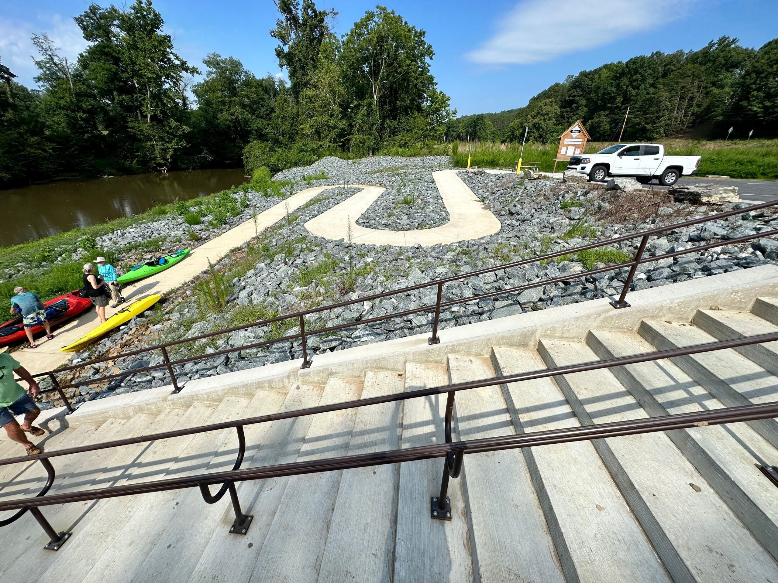
| Abreu-Grogan Park Access | 36.575143, -79.434400 | 3.6 Miles | – | 2020 Memorial Drive, Danville, VA, 24541 | – | Sloped lot parallel to stree. 2 Accessible spaces with access aisles. 10 other spots | Yes – 1 accessible indoor bathroom next to boathouse | 18′ wide ocncrete boat ramp w/ accessible pier. Another smaller ramp for launching rowing boats | Right | DAM AHEAD! DO NOT FLOAT OR PADDLE OVER THE DAM. No portage or downstream river access. |